When opening average radiance imagery in GIS software, people often finds a black rectangular displayed which seems to have no contents. This makes one wonder if the file is corrupted or they have downloaded the wrong file. In fact, this is because most software by default do linear stretch with the detected minimum/maximum values present in the imagery. In the case of Nighttime Light, the max can be hundreds of times larger than the minimum, hence squeezing most of the dimmer lit pixels to the lower end of 8-bit gray scale - which is black. To remedy this, simply set the maximum value in the stretch to a sensible value, e.g. 50, then update the view. This will bring back all the lights on Earth.
For ArcGIS users, please refer to this tutorial.
For QGIS users, please refer to this tutorial.
In EOG, we usually find square-root stretch to be very visually pleasing for it brings up dimmer areas while maintaining the overall gradient. You can use GDAL to apply square-root stretch with min/max set to 0/50 as below.gdal_calc.py -A [image file] --calc="numpy.sqrt(numpy.clip(A, 0, 50))" --outfile [output file]
Usual image viewer and editors expect 8-bit gray scale (or 24-bit RGB color) images. To work with the imageries with various datatypes EOG provides, and to fully utilize the geographical information embedded, it is recommended to use specialized GIS software for inspecting and processing image files downloaded from EOG. Here are some software frequently being used in EOG for image processing.
- ESRI ArcGIS
- Quantum GIS (QGIS)
- ENVI/IDL
Most data in EOG are now required user to have an EOG account in order to download. To register an account please visit this page.
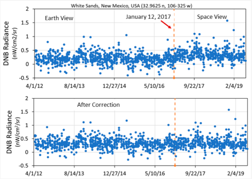
There was a change in VIIRS DNB calibration which effectively raised the noise floor. When dealing with the dim areas this effect is clearly visible in temporal series. EOG had documented this change in Elvidge et a. (2020) [1]. The change is observed after January 12, 2017 as shown in the profile below. That is the date that the dark offset term used in converting the raw counts to radiance was switched from a dark ocean view to a space view, resulting in a slight upward radiance shift [2-4].
[1] Elvidge, C.D.; Hsu, F.-C.; Zhizhin, M.; Ghosh, T.; Taneja, J.; Bazilian, M. Indicators of Electric Power Instability from Satellite Observed Nighttime Lights. Remote Sens. 2020, 12, 3194. https://doi.org/10.3390/rs12193194
[2] Cao, C.; Yan Bai, W.W.; Taeyoung, C. Radiometric Inter-Consistency of VIIRS DNB on Suomi NPP and NOAA-20 from Observations of Reflected Lunar Lights over Deep Convective Clouds. Remote Sens. 2019, 11, 934.
[3] Uprety, S.; Changyong, C.; Yalong, G.; Xi, S. Improving the low light radiance calibration of S-NPP VIIRS Day/Night Band in the NOAA operations. In Proceedings of the 2017 IEEE International Geoscience and Remote Sensing Symposium (IGARSS), Fort Worth, TX, USA, 23–28 July 2017; IEEE: Piscataway, NJ, USA, 2017; pp. 4726–4729.
[4] Geis, J.; Florio, C.; Moyer, D.; Rausch, K.; De Luccia, F.J. VIIRS day-night band gain and offset determination and performance. In Earth Observing Systems XVII; International Society for Optics and Photonics: Washington, DC, USA, 2012; Volume 8510, p. 851012.